(NB: This map overlaps considerably with that of Efrafa to the north, hence the repetition of a couple of points from the previous map.)
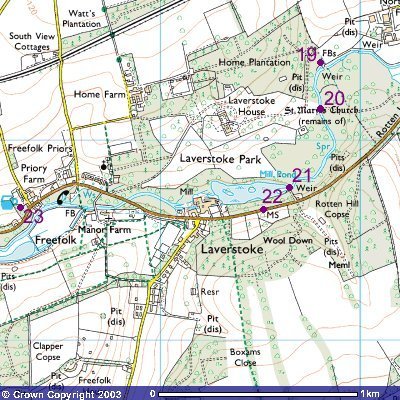
After boarding the punt at point 19, the rabbits drifted downstream in the rain, just barely managing to pass under the bridge they had crossed the previous night (point 20). Two rabbits were struck by the bridge - Acorn, who survived (though his early death in Tales from Watership Down makes me wonder if his constitution did indeed take a knock from this event), and the Efrafan doe Thrayonlosa, who was not so lucky and died the next day.
The brick bridge where the punt came to rest is shown at point 21, with the mill pond beyond that Hazel and Pipkin (followed unexpectedly by Blackavar) were the first to enter. Hazel hoped to stay around here for a while to for the group to recuperate, but this was ruled out for two reasons: firstly, the country around the river was wet and unsuitable for rabbits, and secondly, they were far too close to "a road busier than they had ever known", this being Rotten Hill (point 22), the road into Laverstoke.
And there you have it! I haven't been able to cover all the places mentioned in the book with these maps - Caesar's Belt and Nutley Copse being just two omissions - but I hope I've managed to give readers, especially those less used to the southern English countryside, a flavour of the terrain Hazel's rabbits traversed in the course of the story. All that remains now is for us to retire to the Watership Down Inn at point 23 for a well-earned drink!
Image produced from the Ordnance Survey
Get-a-map service.
Image reproduced with kind permission of
Ordnance Survey and
Ordnance Survey of Northern Ireland.
Copyright © David "Loganberry" Buttery 2003-4. Last updated 06/05/04.