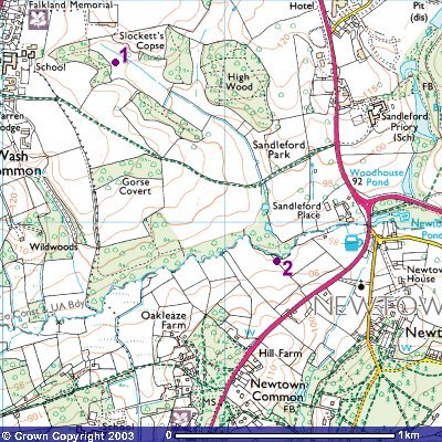
This, of course, is where the story opens, and to this day
the area of the Sandleford warren is thankfully still free of urban
development (you can see the very edge of Newbury town to the extreme NW
of the map). Point 1 marks the precise location of the "dry
slope ... dotted with rabbits" where is located the actual warren.
Slightly to the east is the brook over which the culvert crosses, and
along the course of which the rabbits flee after their initial encounter
with Holly.
Pont 2 is where the rabbits cross the River Enborne on their
makeshift raft. After resting in the beanfield, it would seem that they
then turn roughly eastward, crossing what was then (before the building of
the Newbury Bypass) the A34 (coloured red), and coming across the dead yona. They go
through Newtown churchyard - the scene of the fight with the rats in the
Nepenthe film - and then (perhaps because of the small road close by to its east?) turn south
again, towards Newtown Common, where Hazel's leadership comes under fire
from Hawkbit.
Image produced from the Ordnance Survey
Get-a-map service.
Image reproduced with kind permission of
Ordnance Survey and
Ordnance Survey of Northern Ireland.
Copyright © David "Loganberry" Buttery 2003-4. Last updated 06/05/04.