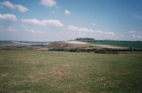
In a way, of course, anything was likely to be an anticlimax after Watership Down itself, and particularly the beech hanger. However, I saw no reason not to enjoy my walk back to Kingsclere, particularly as I was hoping to get there in time to investigate one or two other WD-related sites. In any case, the weather was still kind and the scenery fine. Below you can see the view across from Cannon Heath Down to Cottington's Clump, though its attractiveness has been diluted in recent years by that embleer TV mast.
A little further on, the bridleway ran more closely hugging the northern edge of Cannon Heath Down, and there were some particularly good views over the north Hampshire countryside. Below you can see the scrubby north-eastern slopes of Cannon Heath Down, and then beyond the wooded area (almost another hanger), the buildings of Field Barn Farm in the middle distance, with the outskirts of Kingsclere beyond that. The heavily wooded area on the extreme right of the photo marks the location of Park House Stables.
At last, I had reached the Kingsclere road, and the small car park situated there that is marked on the OS map. However, as with all the other locations, the name "Watership Down" was not mentioned anywhere that I could see; the large information board on the other side of the road mentioning only "White Hill." There was, however, a slightly more informative signpost than usual pointing back towards Watership, as pictured below. The small silver plaque affixed to the post reads, "The Wayfarers Walk was initiated in 1981 by Bill Bodie, Principal Officer for Rights of Way."
I do wonder, actually, whether the total lack of "Watership Down" signs is a deliberate policy on behalf of the local authorities. For one thing, chalk downland is a fragile environment, and it would do the area no good at all to have even more people traipsing up and down it. I suspect, though, that the main reason is a more prosaic one - that as with the street signs in Liverpool's Penny Lane, any "Watership Down" signs would simply be spirited away by misguided WD enthusiasts. After all, Nuthanger Farm had had no sign on the gate either. Whatever the reason, I was inwardly rather pleased by this lack of signage, as it gave a feeling of being in on some wonderful secret known only to those who take the trouble to go and look for themselves.
The walk down the Kingsclere road was reasonably pleasant. Although like most country roads there were no pavements, there was usually good visibility and plenty of time to get oneself up on the grassy verges. The need to do this gave me two unexpected bonuses as well: firstly, as I pressed myself into the bank on the eastern side, a full-grown rabbit lolloped past about twenty feet higher up, taking little notice of either the traffic or me. And secondly, a little further on, on the western side of the road, I turned around and saw this lovely view back up towards Watership Down. It would be the last I would see of this special place today, but I have no doubt that I will be back someday! =:)
The final part of the walk into Kingsclere was level and uneventful, but I was pleased to have made it back to the bus stop in the village centre in time for the 3pm bus. All told, I had spent around three and a half hours on my walk, perhaps walking eight miles or so in this time. Looking at the map, I decided that the obvious aim for the rest of the afternoon was to try to get to Newtown churchyard, and thence to walk back into Newbury via Sandleford.
Copyright © David "Loganberry" Buttery 2004. Updated 07/04/04.